The Project
Author: Janoscha Kreppner | last update: 2023-06-14
The Peshdar Plain Project was inaugurated by Karen Radner (Chair of Ancient History of the Near and Middle East, Ludwig-Maximilians-Universität, Munich) in 2015 within the framework of her Alexander von Humboldt International Award for Research. The impetus for this new field research was provided by the discovery of a Neo-Assyrian private legal contract from 725 BC (in the form of a cuneiform clay tablet) on the western slope of Qalat-i Dinka in the course of agricultural activity, in combination with recent damage to Gird-i Bazar due to the construction of a chicken farm in winter 2014. F. Janoscha Kreppner acted as field director from the its initial excavation in 2015 until 2018, when he accepted the position of Professor of Near Eastern Archaeology at the University of Münster. Since 2018, the Peshdar Plain Project has been co-directed by Karen Radner and F. Janoscha Kreppner. Paid staff members are Andrea Squitieri (Ludwig-Maximilians-Universität, Munich, field director 2018-2020, since 2021 University of Heidelberg) since 2015, digital documentation and small finds, field director 2018-2021, Jean-Jacques Herr (University Munich, 2015-2022), pottery, and Jens Rohde since 2017 (University of Münster and Ludwig-Maximilians-Universität, Munich), excavation and digital documentation, serving as field director since 2021, Jana Richter (University of Münster 2018-September 2022, subsequently Ludwig-Maximilians-Universität Munich), micro-debris, Ellen Coster (University of Münster) since 2021, pottery DLT-2, and Tarik Willis (University of Münster) since 2021, excavation and documentation in DLT-2. The work is conducted under the auspices of the Directorate of Antiquities of Sulaymaniyah, directed by Kamal Rasheed Raheem until 2022, and by Hussein Gharib since 2022. The Peshdar Plain Project also enjoys the support of the General Directorate of Antiquities of the Kurdish Autonomous Region of Iraq, currently directed by Kaifi Mustafa Ali, and of the Raparin Directorate of Antiquities, under the direction of Barzan Baiz Ismail.
Further Reading
Research Goals & Methods
Author: Janoscha Kreppner | last update: 2022-11-21
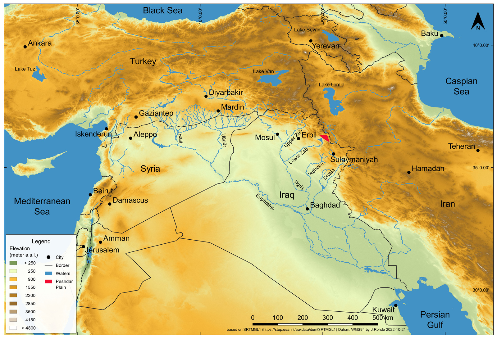
The object of our investigation is a major Iron Age settlement located in the Peshdar Plain in the Kurdish Autonomous Region of Iraq, on the border with Iran. Archaeological investigations were initiated in 2015 by Karen Radner with the interdisciplinary "Peshdar Plain Project" with the aim of investigating the borderland processes and the cultural and political transformations on the eastern frontier of the Neo-Assyrian Empire, which expanded into this region in the late 9th century BC. The ancient name of the settlement is presently unknown. Because its perimeter encompasses two previously identified archaeological sites, Gird-i Bazar and Qalat-i Dinka, we refer to it as the “Dinka Settlement Complex”, after the larger of these sites.
The Peshdar Plain Project brings together international experts in history, archaeology, bioarchaeology, landscape archaeology, geophysics, GIS, photogrammetry, and 3D modelling.
The Peshdar Plain Project has intensively investigated the ancient environment of the Bora Plain through the use of geophysical methods, coring, soil and sediment analysis, and geological surveying. The aim of these environmental is to clarify the geological setting, the formation processes of the alluvial Bora Plain, and the relationship between the Dinka Settlement Complex and its surroundings. The objective of our excavation strategy is to reconstruct the biographies of the buildings and to locate activity areas. The colour, density and consistency of the soil is documented to interpret the formation processes of the archaeological record. Soil deposits on floors – so-called suprafloors – are of particular importance, since they provide information about how the inhabitants used spaces like outdoor areas, courtyards, and rooms. The excavation employs a bioarchaeological sampling strategy, with strict gridding protocols for the floors. This facilitates the collection of organic data, including, most importantly, phytoliths, bones, charcoal, and other palaeobotanical remains.
An important aspect of the Peshdar Plain Project excavations was the establishment of a digital documentation and registration system based on an online-MySQL Database. Maps, plans and orthophotos have been created with the open source geographic information system (GIS) application QGIS and the photogrammetry software package Metashape.
Further Reading
Funding
Author: Janoscha Kreppner | last update: 2025-11-25
First project phase 2015-2020
Main funding
- Alexander von Humboldt Foundation and LMU Munich, with the Alexander von Humboldt Professorship award received 2015 by Karen Radner
Additional funding
- the Munich University Society
- the Gerda Henkel Foundation:
- AZ 42_V_16 "In the Assyrian border march of the palace herald: Rescue excavation at Gird-i Bazar"; Applicant: Prof. Dr. Karen Radner (LMU Munich)
- AZ 09_V_19 "Imperial Border Protection, 900-600 BC: Towards an understanding of Assyrian Fortification and Defence Strategies in the Age of Empire"; Applicants: Dr. Andrea Squitieri and Dr. Jean-Jacques Herr (LMU Munich)
- European Union's Framework Programme for Research and Innovation Horizon 2020 (2014-2020) under the Marie Skłodowska- Curie Grant Agreement No. 754388 (LMUResearchFellows) and by LMUexcellent scheme, funded by the Federal Ministry of Education and Research (BMBF) and the Free State of Bavaria under the Excellence Strategy of the German Federal Government and the Länder award received by J.-J. Herr in 2019 for the pottery study (Gird-i Bazar).
- Rust Family Foundation Archaeology Grant (Fairfield, Connecticut) awarded to Andrea Squitieri and Mark Altaweel (UCL)
- appointment funds Florian Janoscha Kreppner (University of Münster)
Second project phase from 2021-2026
Main funding
- German Research Foundation (DFG) research project number 453121830 “Lifeworlds of the early first millennium BC in the western Zagros Mountains on the Lower Zab before and after the Assyrian annexation: The civil centre of the ”Dinka Settlement Complex in the Peshdar Plain"; Applicant: Florian Janoscha Kreppner
Additional funding
- Chair Karen Radner (LMU Munich)
- Gerda Henkel foundation
- AZ 08/V 120 Graphic design of a website and implementation of an interface to the database of the Peshdar Plain Project for communication of research data; Applicant Prof. Dr. Florian Janoscha Kreppner
- AZ 42/V/20 Using Electrical Resistivity Tomography and Sediment Coring to explore the prehistory of the Dinka Settlement Complex in Iraqi Kurdistan; Applicants Prof. Dr. Karen Radner (LMU Munich), Prof. Dr. Jörg Fassbinder, Dr. Andrea Squitieri
Further Reading
Deutsche Forschungsgemeinschaft, Gerda Henkel Stiftung, Alexander von Humboldt Stiftung, Münchner Universitätsgesellschaft, Rust Family Foundation as well as Ludwig-Maximilians-Universität München (LMU) and Westfälische Wilhelms-Universität (WWU) Münster
Campaign 2023
Author: Janoscha Kreppner | last update: 2023-11-20
Second phase of the project 2021-2024
During the second phase of the project, 2021-2024, the following excavation and prospecting campaigns were carried out:
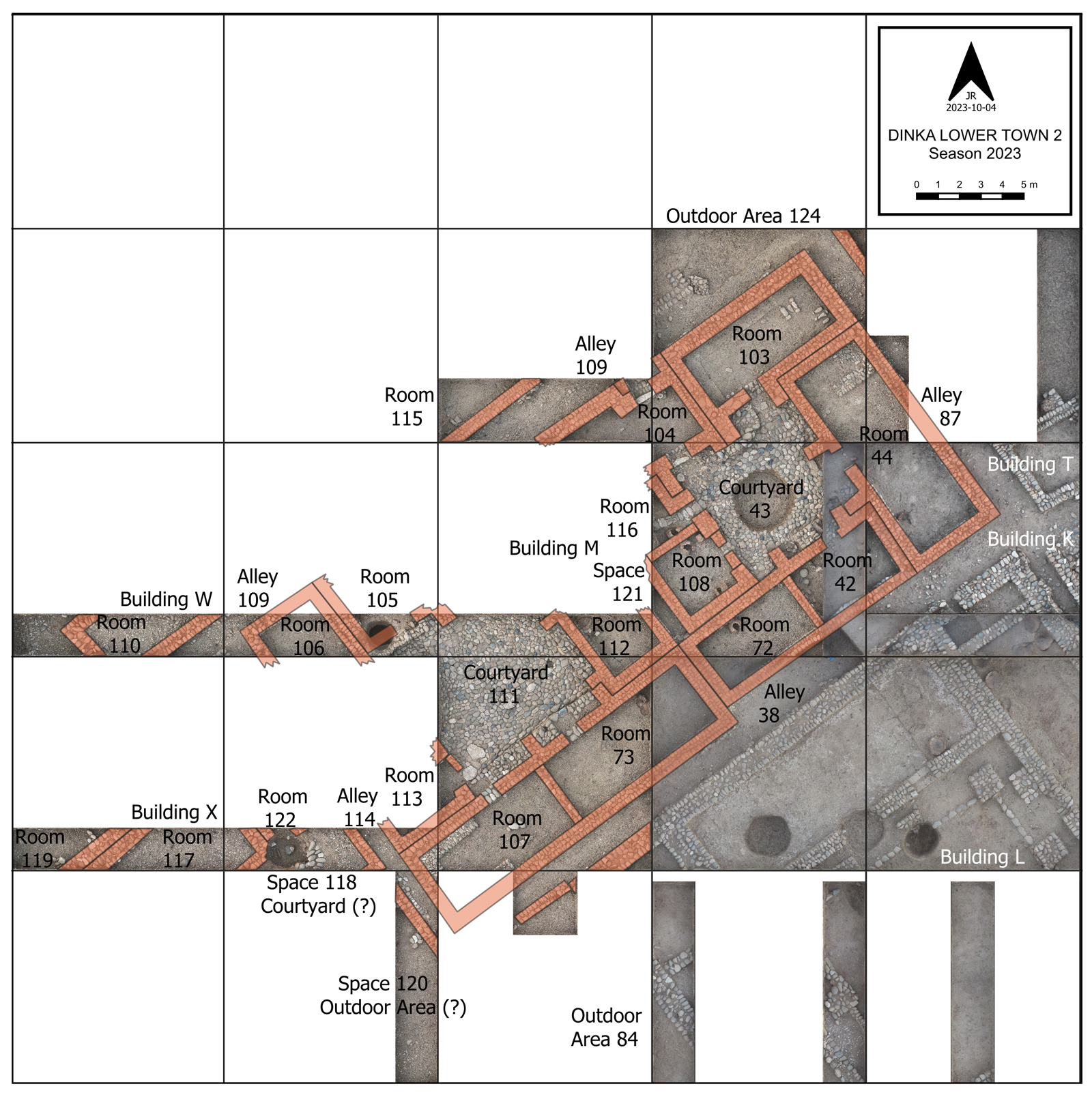
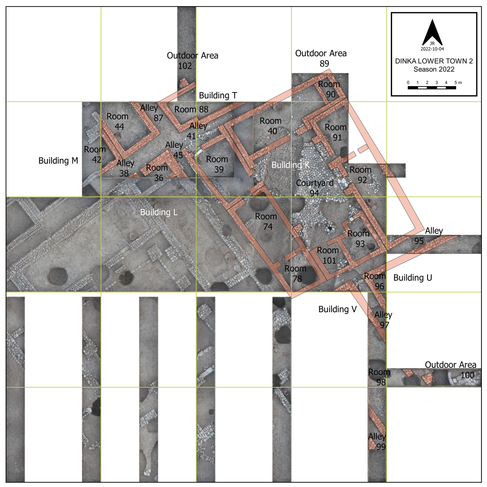
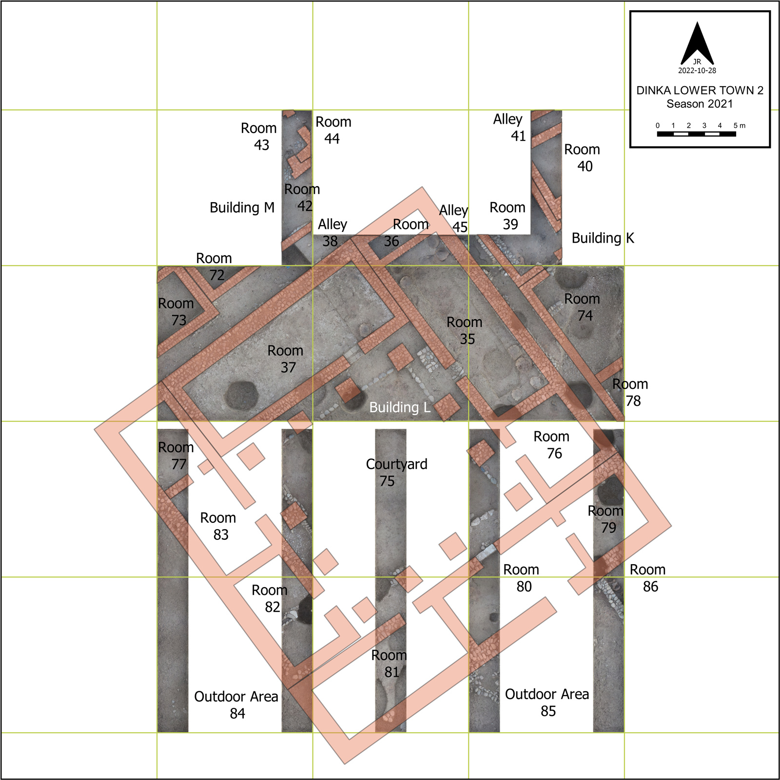
2023 Dinka Lower Town Campaign (DLT2): Building M
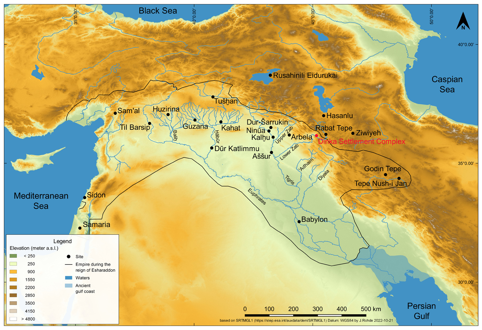
The third campaign of the research project funded by the German Research Foundation entitled "Lifeworlds of the early 1st millennium BC. C. in the western Zagros Mountains on the Lower Zab before and after the Assyrian annexation: The civil centre of the Dinka Settlement Complex in the Peshdar Plain" took place from 17 August to 11 October 2023. The aim of the campaign was to gain insights into the functions of Building M located in "Dinka Lower Town Operation 2 (DLT-2)" on the northern edge of the lower town of the approximately 60-hectare Dinka Settlement Complex through excavations. Building M forms an ensemble with Buildings L and K, which were previously the target of excavations in spring 2017, autumn 2021 and autumn 2022. The material culture unearthed during these excavations is evidence of a hitherto little-studied Iron Age local community in the western Zagros Mountains. 14C dating shows that the buildings were in use in the period ca. 1050-820 BC.
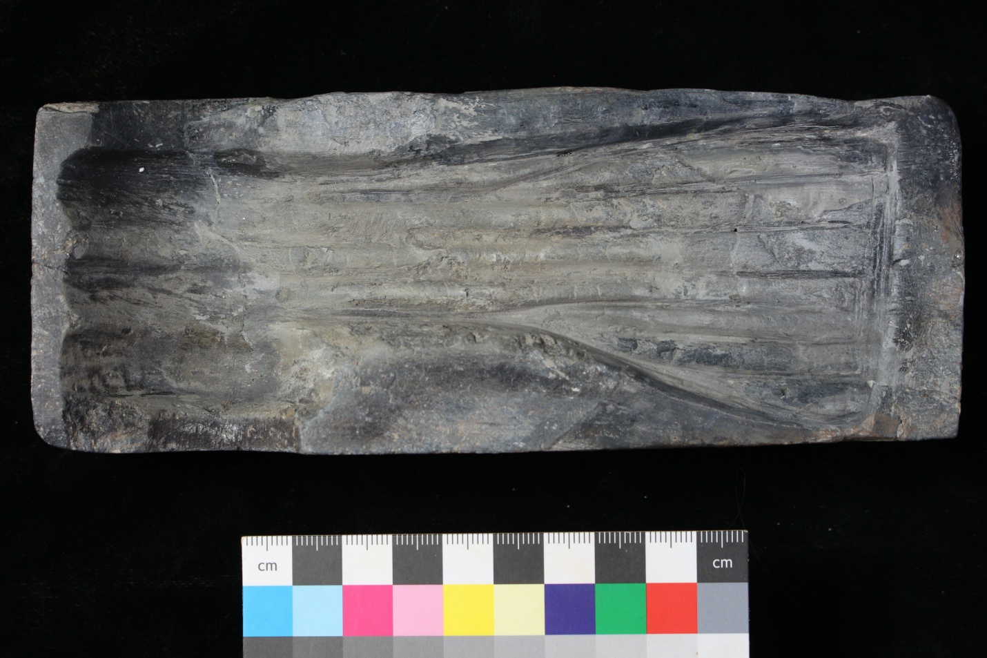
During the 2023 campaign, an area of 450 m2 was excavated, covering parts of Building M and neighbouring areas in test trenches. This brought to light well-preserved remains of a well-planned building surrounded by alleyways, the floor plan of which covered an area of 530 m2. 13 rooms were grouped around the two central Courtyards 43 and 111. Rooms 103, 44 and 107 were identified as storage rooms by clay or stone benches in front of the boundary walls and large quantities of pottery from large storage vessels. Rooms 44, 72, 73, 112, 108 and 116 are characterised by round ovens with a diameter of approx. 50 cm, which were probably closed at the top like a dome and had an opening at floor level. The furnaces and 29 stone moulds, many of which are only preserved in fragments but also some complete moulds, testify to the fact that Building M housed a metal workshop.
In addition to Building M, Building K also features numerous furnaces of the same type in several rooms, which suggests that it was also involved in metalworking activities. Both buildings flank Building L with a large representative room and a large storeroom. According to the geophysical prospection, Buildings K, L and M are the largest in the lower town, which suggests a central importance for the settlement and possibly a central organisation of metalworking. The buildings were used in a time when the resource-hungry Assyrian Empire was expanding from its heartland in the northern Mesopotamian lowlands into large parts of western Asia. The Dinka Settlement Complex obviously benefited from the favourable location with metal ore deposits in the nearby mountains on the one hand and the Lower Zab River and other transport routes on the other, via which products could be traded to the Mesopotamian lowlands. The new results of the 2023 excavation campaign in Building M of the Dinka Settlement Complex will serve as a basis for further research on the production and trade of metal artefacts in West Asia in the early first millennium BC.
Campaign 2022
Author: Janoscha Kreppner | last update: 2025-06-17
2022 Dinka Lower Town Campaign (DLT2): Building K
The second campaign of the research project funded by the German Research Foundation (DFG, research project number 453121830) “Lifeworlds of the early first millennium BC in the western Zagros Mountains on the Lower Zab before and after the Assyrian annexation: The civil centre of the Dinka Settlement Complex in the Peshdar Plain” took place from mid-August to mid-October. The target of the 2022 excavations was Building K. During this campaign, an additional 450 sqm area was excavated, complementing the 2017 and 2021 excavations in DLT-2.
Building K has a roughly rectangular plan with a side length extending about 20 m from NW-SE and 17 m from NE-SW. The excavation results provide insights into the architecture, construction, and spatial organisation of the building. Nine rooms are arranged around a central courtyard. The building could be accessed from an alley to the northwest. The entrance was equipped with a large white stone threshold. The construction is divided into five building units, each enclosed by perimeter walls. The building units meet in double walls and are separated from each other by construction joints. Building unit 1 corresponds to Room 39, building unit 2 consists of Rooms 40 and 90 and building unit 3 of Rooms 91 and 92. Building unit 4 with Rooms 93 and 101 and building unit 5 with Rooms 78 and 74 are much worse preserved. The interface of these two building units in particular is essentially based on reconstruction. The fact that there was only one floor in each room, which was connected to those of the neighbouring rooms via passages, establishes that Building K was occupied for one phase of use. The building units should be regarded as elements within an overall plan, which were constructed either simultaneously or within a short time of each other. The high density of furnaces in Rooms 91, 92, 93, and Courtyard 94 suggests that intensive activities requiring fire and heat took place in Building K. The existence of a well in the courtyard and the - as far as it is preserved - extensive stone paving indicate that water was involved in the work processes, too.
Further Reading
Kreppner, Florian Janoscha; Rohde, Jens; Coster, Ellen; Willis, Tarik (2025), The 2021 and 2022 Excavation Campaigns of the Peshdar Plain Project in the Lower Town of the Iron Age Dinka Settlement Complex on the Eastern Frontier of the Assyrian Empire. In: Ingolf Thuesen, Scott Haddow, Camilla Mazzucato (eds.), Proceedings of the 13th International Congress on the Archaeology of the Ancient Near East, 22–26 May 2023, Copenhagen. Wiesbaden: Harrassowitz-Verlag, 191-202.
https://www.harrassowitz-verlag.de/ddo/artikel/88533/978-3-447-12376-1_Free%20Open%20Access%20Download.pdf
Campaign 2022 spring
Author: Janoscha Kreppner | last update: 2024-11-18
2022 Spring Campaign
In spring 2022, a campaign took place from the end of February to mid-March, during which two activities were carried out: first, the use of electrical resistance tomography and sediment coring to investigate the prehistory of the Dinka Settlement Complex in Iraqi Kurdistan; and second, the processing of the ceramics of Building L (DLT-2).
Campaign 2021
Author: Janoscha Kreppner | last update: 2025-06-17
2021 Dinka Lower Town Campaign (DLT2): Building L
In autumn of 2021, the first excavation campaign of the research project funded by the German Research Foundation (DFG, research project number 453121830) “Lifeworlds of the early first millennium BC in the western Zagros Mountains on the Lower Zab before and after the Assyrian annexation: The civil centre of the Dinka Settlement Complex in the Peshdar Plain” took place. The focus of the 2021 excavations was one of three buildings in the lower town which are obviously larger in size than the currently excavated houses and workshops or buildings visible in the magnetometer plan, and therefore might have performed a central function for the lower town. The building studied is quadrangular, covers an area of 700 sqm, and had large exposed sections. A central 215 sqm courtyard is enclosed on all four sides by a row of rooms. Along the courtyard walls, an area about 1.7 m wide is demarcated by a row of stones carefully set into the ground. At regular intervals along the perimeter are square stone pedestals that may have served as the base for pillars that supported a ceiling structure. This suggests that the courtyard was once surrounded by a perimeter portico. Two rooms of Building L were almost completely uncovered and deserve special mention. Room 37 is particularly elaborate due to its size of approximately 60 sqm, a door threshold made of burnt bricks, a floor covering of white lime, and a podium on the northeastern narrow side; it can be interpreted as a representative reception room. Room 35 probably served as a central storehouse, as evidenced by the remains of a large number of large pithos vessels. Building L was therefore part of the civil centre of the lower town of the Dinka Settlement Complex. Clear traces of fire suggest a violent end of use, possibly as a result of the Assyrian annexation.
Building L differs in plan and construction from previously known Iron Age architectural traditions such as Mesopotamian courtyard houses in the west and buildings with central pillared halls in northwestern Iran. Both elements are combined here to form a courtyard with a portico: Building L thus provides new insights into the building tradition and socio-cultural organization of indigenous society in the Zagros at the interface between Mesopotamia and western Iran.
Further Reading
Kreppner, Florian Janoscha; Rohde, Jens; Coster, Ellen; Willis, Tarik (2025), The 2021 and 2022 Excavation Campaigns of the Peshdar Plain Project in the Lower Town of the Iron Age Dinka Settlement Complex on the Eastern Frontier of the Assyrian Empire. In: Ingolf Thuesen, Scott Haddow, Camilla Mazzucato (eds.), Proceedings of the 13th International Congress on the Archaeology of the Ancient Near East, 22–26 May 2023, Copenhagen. Wiesbaden: Harrassowitz-Verlag, 191-202.
https://www.harrassowitz-verlag.de/ddo/artikel/88533/978-3-447-12376-1_Free%20Open%20Access%20Download.pdf
Campaign 2015-2019
Author: Janoscha Kreppner | last update: 2022-11-21
First phase of the project 2015-2020
During the first phase of the project 2015-2020, the following excavation and prospecting campaigns were carried out. Preliminary reports are hosted at LMU Munich:
- 2019 Dinka Settlement Spring Campaign | 2019 Dinka Settlement Autumn Campaign
- 2018 Qalat-i Dinka Spring Campaign | 2018 Dinka Lower Town Campaign (DLT 3)
- 2017 Dinka Lower Town Campaign (DLT 2) | 2017 Gird-i Bazar Campaign
- 2016 Qalat-i Dinka | 2016 Gird-i Bazar Campaign
- 2015 Campaign